
Hiking to Jocelyn Hill in Gowlland Tod Provincial Park
On the slopes of Jocelyn Hill there are absolutely stunning views of Greater Victoria, Juan de Fuca Strait and the Olympic Peninsula. To the west you can look down into Finlayson Arm all the way to the Goldstream Estuary and Mount Finlayson. A short walk to the north side of the summit will reward you with an amazing vista across Saanich Inlet all the way to the snow capped peaks of the Coast Mountains on the mainland.
Jocelyn Hill
Jocelyn Hill is a 424 m (1391 ft) peak in the Gowlland Range, located in Gowlland Tod Provincial Park, part of the greenbelt of parkland running from near the southern end of Finlayson Arm all the way north to Tod Inlet.
There are three ways to access Jocelyn Hill. One from the southern end of the park at Caleb Pike (9.2 km return), the middle and shortest route starting on the Emma Dickson trail (5.5 km return) and the longest and most grueling, starts at the McKenzie Bight parking area on Ross Durrance Rd (12.4 km return).
Optionally, you can drop a car at one end drive to the other and hike the whole thing from Caleb Pike, up and over Jocelyn Hill, and finish in McKenzie Bight (about 11 km total). That’s a trek Linda and I did many years ago. This post covers the grueling 12.4 km route from McKenzie Bight to Jocelyn Hill and back.
The McKenzie Bight to Jocelyn Hill Route
The Timberman Trail to Jocelyn Hill begins near the McKenzie Bight parking area on Ross Durrance Rd, just off Willis Point Rd. You can park in this lot or continue past it a short distance (about 0.3 km) where you will find some off road parking. This packed dirt area is directily across the road from the gate at the start of the trail.
Park Map
The Timberman Trail
The first section of the trail from the gate to just past the Cascade Trail Junction is an easy walk through lush west coast forest. This is all second growth forest and you will see lots of signs of logging from the past. This probably accounts for the trails name. This portion of the trail is a good warm up for what is to come.

Signs of past logging on the early section of the Timberman Trail
At the Cascade Trail Junction, just across the bridge over Pease Creek, there is a sign post and map. We talk about the Cascade Trail in another post (check it out). Carry on straight ahead and in about 10 or 15 minutes you will begin to climb steeply. The trail is relatively good but there are a lot of exposed rocks and tree roots and the climb is relentless!

Jocelyn Hill & Cascade Trail junction sign

Timberman Trail before the steep uphill section begins

Along the steep climb
Unfortunately, while the walk through the forest along the ridge is beautiful, don’t expect a lot of views of the inlet or great places to stop for breaks. On the BC Parks map you will see the Saanich Inlet View Point marked, but the view here is mostly blocked by trees. At one time these points were probably quite open but with time things change, especially in a rain forest.

The Saanich Inlet Viewpoint’s views are obscured by trees
The Timberman Trail eventually tops out on the ridge continuing along with some ups and downs. It eventually leads into a lush ravine where it crosses a wooden bridge over a small creek. In another 15 minutes or so you will come to a trail sign indicating Jocelyn Hill to the left and Squally Point View Point straight ahead. You are now at the half way point.

The trail begins to level out
Squally Reach Viewpoint
It’s definitely worth the short (100m) climb up to the Squally Reach Viewpoint (check out our post). This is a great place to stop for a break and check out the views of Squally Reach and Saanich Inlet. They are incredible!
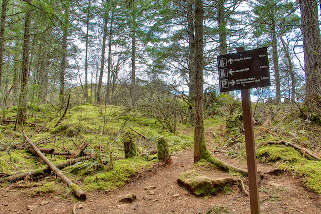
Trail sign below Squally Reach Viewpoint
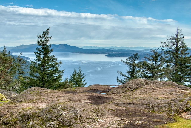
Saanich Inlet from the Squally Reach Viewpoint
Leaving the Squally Reach Viewpoint, turn right and continue towards Jocelyn Hill. The trail winds through some lovely forest as it works its way around the mountain. There are a couple of steep rocky sections to negotiate, but by and large the trail is quite decent and you will find a couple of good viewpoints looking east towards Mount Work and even Mount Baker in Washington on clear days.

Timberman Trail as it begins to wrap around Jocelyn Hill

A partially obscured Mt Baker seen from the Timberman Trail

Steep rocky section of the Timberman Trail on Jocelyn Hill
You will eventually reach another junction with a sign and map. This will lead you up the to the top of Jocelyn Hill. Be sure to look around as you are climbing as your first good views will appear behind you looking south towards Victoria and Mount Finlayson.

Timberman Trail & Jocelyn Hill junction

First views towards Victoria on the way up Jocelyn Hill – looking across Lone Tree Hill
The Jocelyn Hill Summit
Before the actual summit you will be able to climb up onto a smooth rocky area with great views south at Greater Victoria, Mt Finlayson and the Olympic Peninsula. It’s a great spot to stop for a break and spend some time taking in the views. However, you are not finished yet! Continuing north, the trail winds around the summit of Jocelyn Hill coming to a small rocky outcrop, the Jocelyn Hill Viewpoint, with stunning views north across Saanich Inlet right to the Coast Mountains on the mainland!

Looking south at Mount Finlayson & the Olympic Peninsula from the rocky outcrop on Jocelyn Hill

Beautiful Arbutus Tree near the summit of Jocelyn Hill

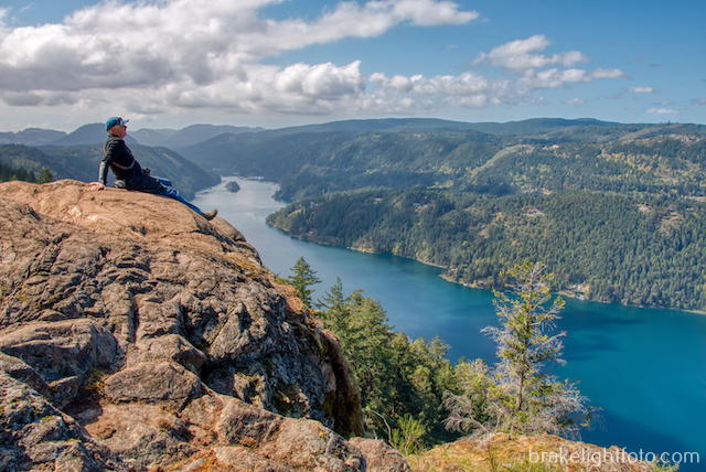
The Jocelyn Hill Viewpoint

Jocelyn Hill Viewpoint – looking across Saanich Inlet
The Return Route
After enjoying the views, you can either return the way you came or turn right off the viewpoint and follow the trail down a short steep decent. This will take you around the west side of the summit coming to the junction with the Lower Jocelyn Hill Loop Trail. The best views of Finlayson Arm are along this section of trail. Turn left at this junction, then within about 0.3 km take another left which returns you to the Timberman Trail and the trek back to McKenzie Bight (about 5.0 km).
Finlayson Arm from Jocelyn Hill
Alternative Routes back to McKenzie Bight Parking
There are other routes back to McKenzie Bight which we will cover in another post. However, these are old trails which are not shown on the provincial parks map and are not well maintained. They have some very steep sections and in many places there are fallen logs and debris across the trail. That being said, they are still passable, well used and many of the old trail signs are still there. They can make for some interesting exploration. These trails are shown on mapping apps such as AllTrails and Maps.Me.
